Cleveland, Ohio — The heat will return to Northeast Ohio on Saturday and Sunday, with heat indices approaching 100 degrees due to higher humidity.
High pressure off the East Coast is influencing the weather in Northeast Ohio, but a cold front expected late Sunday into Monday will bring change.
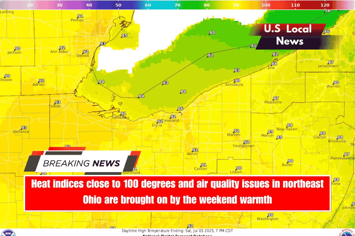
Forecasters at the National Weather Service in Cleveland predict temperatures to rise into the upper 80s to lower 90s on Saturday.
Forecasters expect a light lake breeze to develop across Northeast Ohio, keeping temperatures just a few degrees cooler.
Afternoon heating may produce some showers and storms off the lake breeze Saturday afternoon, but overall rain coverage is expected to be low, according to forecasters.
Lake Erie will be a great place to cool off this weekend, with water temperatures in the 60s near Cleveland and 70s closer to Toledo and Erie, Pennsylvania. Boaters can expect calm conditions and low wave heights over the weekend.
Air quality advisory issued Saturday
Heat, light winds, and residual firework smoke have prompted the Northeast Ohio Areawide Coordinating Agency to issue an air quality advisory for Ashtabula, Cuyahoga, Geauga, Lake, Lorain, Medina, Portage, and Summit counties until Saturday, July 5.
AirNow.gov predicts that the air quality in Cleveland, Akron, and Lorain will become “unhealthy for sensitive groups” during the day, despite being in the “moderate” range on Saturday morning.
According to AirNow.gov, people with lung disease, children and teenagers, older adults, and those who spend six or more hours a day outside should reduce their exposure by engaging in less strenuous activities or shortening their time outside.
Heat continues Sunday with storms possible
Forecasters predict that hot conditions will persist on Sunday, with more locations experiencing heat index values in the mid to upper 90s.
Showers and thunderstorms are likely on Sunday afternoon and evening as a weak low pressure system moves into the central Great Lakes region. This will be accompanied by a rise in instability from west to east.
Forecasters said the highest chance of precipitation will be west of the Interstate 71 corridor late Sunday.
Higher chance for showers and storms Monday
The weather pattern will shift Monday as a cold front moves through, increasing the likelihood of showers and thunderstorms. Cloud cover may limit how unstable the atmosphere becomes, but there is still enough energy for storms to form, forecasters say.
Some of these storms could produce heavy rain, while others could be strong to severe. Forecasters are also keeping an eye out for training storms, which occur when a series of thunderstorms move over the same area in succession, similar to a train and its cars moving along a track.
The repeated passage of storms can result in excessive rainfall and localised flash flooding because the same area becomes saturated with rain from multiple storms.
Monday’s temperatures are expected to be in the low to mid 80s, with high humidity making it feel muggy.
By Tuesday, the cold front is expected to be south of the area, leaving most areas dry. Temperatures will gradually moderate as high pressure builds in, resulting in slightly more comfortable conditions with highs in the 80s and lower humidity.